October2025
Weather diary page
Oct 1, Northern Rivers: The dry run is starting to become weird. Especially as the forecasters were predicting a wet spring courtesy of the Indian Ocean dipole. Instead, the way it transitioned so suddenly from incessant rain, basically since Easter, to a complete dry-out at the start of Sep, is not something i've seen before. It's due, supposedly, to sudden warming in the stratosphere above Antarctica, causing a negative Southern Annular Mode (SAM).
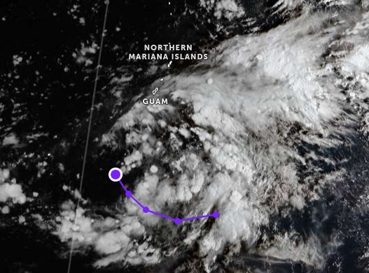
Oct 8, Guam: We're getting more sun the last few days but still plenty of rain. I've been watching how storms and typhoons often start forming right in our area. Currently there's Halong which is east of Japan but I believe formed near us, and closer to home we have as yet Unnamed 95W which was SE of us a couple days ago and has now moved NWW of us and formed up. This must be why Guam doesn't regularly get hit by typhoons. They don't often form far enough SE of us to hit, with Mawar (2023) being the most recent exception. Zoom.earth seems to identify potential systems days before other sites like JTWC.
Oct 8. NR: Cool, Dan has arrived at the genesis point of typhoons - which is way better than the other end. Be considerate on how you direct them. Pecans started releafing about a week ago - there's now a visible tinge of green. Scarlett honey-eaters have left. Less finches. Channel-billed cuckoos arrived arrived Oct 1-2. Tonight, frogs started croaking, which is weird, coz there hasn't been a drop of rain for over a month - do they know something? No rain is forecast - 30C thereabouts every day - no significant rain predicted.
Oct 14, Guam: Typical example of a system forming right in our front yard:
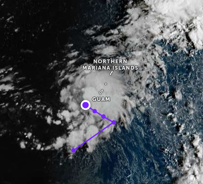
Oct 15, Guam: Formation is continuing. 96W according to JTWC. We're getting very heavy rain. I read somewhere long ago that Guam is on a permanent 24-hour typhoon notice, meaning a typhoon could hit within 24 hours. And yet, it only gets hit by a serious typhoon a couple times a decade.
Oct 25, NR: The snap dry continues - def the driest stretch i've seen since i've been here with barely any rain since beginning of Sep. Water tank ran dry a week ago - it was full to the brim at the start of Sep, so it takes 6-7 weeks to empty (two people) if no rain. Finally bought a transfer pump to move water from shed gravity feed tank to main tank - that should tide us over until we get a decent storm. Some rain forecast in coming days. Koels have appeared in the last week - or at least started calling. Mulberries coming towards the end - been making jam & juice. Last fire was around middle of Oct, which is late. Days are mostly around 30 though today has dropped to 25. 35 expected tomorrow with possible storm. Massive rain in Taipei the last week as their summer finally broke - up to 2000mm in Shilin over 5 days - combo of dong bei ji & southern typhoon - similar to what caused the road collapse disaster on the Su Hwa highway in Ilan about 15 years ago.
Oct 30, NR: The drought has broken, & that is likely the end of it. Kinda sorry to see it go. Big rain (50mm?) on Oct 28 that 2/3rds filled the tank. Before that, grass was starting to turn yellow, which is very rare here. It also meant it wasn't growing, which was great coz no need to cut it when normally i'd be cutting every 2 weeks at this time of year. Can expect it to shoot up now. Follow up rain forecast for the coming days. No real storms yet though there was one bolt of lightning a few days ago that was very close to the house - about half way between house & the rock. Saw a sacred kingfisher yesterday. Pecan are virtually back to full leaf.
Oct 31, Guam: We've had a noticeable increase in sunshine in the last week of October, but with systems still bringing us heavy rain. This is in line with yearly averages which see siginicant drop in rain starting in November.