Main /
June2012
Weather diary page
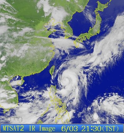
- June 3 - Typhoon Mawar is sitting SE of Taitung, heading in a NNE direction, expected to shift NE in a day or two. Currently we're getting gusty NE and sometimes NW winds with intermittent rain in Donghe. Generally unstable weather. 2000 update: Outer bands of Mawar not far off the coast, very unstable air, clouds moving in from the west while wind is from the north.
- June 5 - 50+mm of rain recorded at Changbin station as of 1700. It didn't rain all day in Zhiben. Very muggy morning - even by Taiwan's high standards. Started raining in XC about 3.30pm, light at first, but became heavy and sustained around 5. 50ml in XC as of 7.50pm. Love to know the exact conditions that have caused this. No cold fronts around - typhoon is far away and moving further away, and the rain was mainly confined to central-north TD and Hualien. Has dropped off to light rain now, but lots of thunder and lightning around. Light, variable southerly winds accompanied the initial downpour. Obviously some special conditions at play - may be that the tail of the typhoon has created a slipstream of air that's drawing moisture from the south? Seemed to be an extreme low tide today (it's a full moon) - lots of people out gathering shellfish from the exposed rocks around midday.
- June 7 - Lots of prime wood has been on the beaches the last couple of days. I'm not sure to what extent the full moon had to do with it, but the concurrent high tide was particularly strong. The rock hunters were out in force during low tide in the early afternoon, and they weren't weekenders. They came with their special digging tools and other gear. How did they know? Whatever brought the rocks in also brought the wood in.
- June 9 - Very humid, hot weather. Last night was unusually stagnant with a variety of hungry bugs out and about. There has been a significant amount of earthquake activity in southern Taiwan lately, for whatever that is worth. The first potentially major typhoon is brewing about 2,800 KM east of the Philippines, moving west at 28KPH.
- June 10 - 6.5 earthquake off the coast of Ilan at 5am to start the day (see Dan's theory on forum board). Despite predictions, even warnings of extreme rainfall in Taipei it was thankfully dry, though there were massive falls in pingdong (600+ and very much still counting)and widespread rain across the rest of the island. Drove back from Taipei to Taidong late at night and the rain was building along the way and the lightning flickering ominously over the southern ranges. Managed to get thru the Su Hwa highway without drama (wipers on, but not full speed) though the flashing lights were on at the gates. Charts show atmosphere to be very unstable (see mei yu thread) and this looks like the mei yu's grand gesture of the season. Back home and it's 4.30am and there's this extra long rumbling thunder to the west. Dan will be getting up in a minute - he can take over.
- June 11 - Sandimen in Pingtung County has gotten well over 800 in the last 48 hours with more to come today. Taitung County has been spared the heavy rain, but it's been raining steadily for two days now. We've gotten maybe 150-200 in Donghe total.
- June 14 - The stationary front that has been bringing us torrential rain is living up to its name. I thought the worst of the rain had passed but it's pouring this morning in DH. Locations in Pingtung and Kaohsiung counties have probably gotten well over 1500 in the last few days, with more to come. Typhoon Guchol is heading in this direction, but it is supposed to curve north before reaching Taiwan. Hopefully it will take some of this rain with it.
- June 15 - It just keeps raining. On top of that, Haulien has had nearly fifty, 50, earthquakes in the last 13 hours. And there's a typhoon coming. The good news is that I can't see any way that locusts could fly in this rain. As it turned out, this was the last of the mei yu rain - certainly went out with a bang.
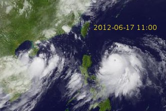
- June 17 - It's been mostly dry the last couple of days and very humid. The sun is out today but there are extreme rain warnings out for the whole island. Typhoon Guchol will be affecting us in a few days,and there is a menacing low, 92W, east of Hainan Island. There is a chance it could move in our direction.
- June 18 - Dry, sunny morning.
- June 23 - Guchol has been gone since the 21st. We're getting a warm, sunny, and extremely windy (south wind) day. In fact the gusts we've had today are far stronger than anything Guchol gave us.
- June 25 - The summer weather pattern of hot, blazing sun has started. Yesterday morning, the winds were stiff and out of the south, but by evening at started coming from the NE. This morning the winds are still out of the NE. That seemed unusual. Theresa saw what we think were two whales jumping off the Jinzun coast. She was walking to the beach and looking out from an elevation of a couple hundred feet (just above Rt. 11), so she had good visibility. She couldn't positively identify them as whales, but they did make a big reentry splash, so I'm not sure what else they could have been. They were out much farther than the fishing boats. Afternoon thunderstorm pattern has started in the north, west, and south - but that's not something we get on the mid-south east coast - unfortunately. Our only relief for the next few months will come from cyclones. There is something forming to the south east - hopefully get something out of that.
- June 26 - Hot. The big bake is well and truly on - 4-5 days of day long sun with little cloud cover. System building to the SE heading this way. Could be big. Intrigued by this fairly stiff ne breeze that has blown in just on evening a few times recently - happened again today. It's nice - i hope it continues. Haven't heard any nightjars for a while.
- June 27 - hot
- June 28 - hot and windy. Murphy's law is in full swing today as yesterday i just put up a stack of black shade cloth around the house but awoke this morning to find that the house was about ready to lift off from the force of the wind under the cloth. Needed to take it all down again, which was a scary exercise in itself. Gusts of around 50-60kmh coming out of the NE. Originally assumed the wind was somehow associated with the typhoon - air rushing into the low pressure rather than actual typ generated wind - but JTWC refers to the wind as unassociated and in fact it is causing strong vertical windshear and creating a 'hostile environment' for the typhoon. Typ has moved west overnight and is currently making landfall on the northern tip of ppe. Had expected it to break up to some degree resulting in fragments drifting north and hopefully producing rain here, but this powerful VWS is messing that up and not only degrading the typhoon but blocking the poleward outflow that would have produced rain here. Annoying.
- Rest of June: Hot.